Mount Rinjani is one of Indonesia ‘s 129 active volcanoes. It is considered sacred by both Hindus and Muslims. With an altitude of 3726 meters, it has one of the most popular mountain climbing routes in South Asia. There is a 6 km wide crater on the summit of this active volcanic mountain, located in the north east of Lombok Island.
Millions of years of eruptions and erosion over time have created stunning landscapes and crater lakes on this second-highest volcano in Indonesia. There is an active volcano called Gunung Baru, 700 meters below the summit, right next to the lake in the crater. The region was declared as a national park area in 1997.

We aim to climb to the top of the active volcanic Rinjani Mountain, which is the most important activity to be done on the Indonesian island of Lombok. Together with my travel mate Farid, we came to the town of Senggigi from the Gili Islands. This is an affordable place to relax, get things done that requires internet, and swim and relax.
In the last few days, I negotiated with my Dutch friend Farid with travel agencies and got the prices of climbing tours in the form of 2 nights, 3 days or 3 nights and 4 days. Prices offered to us range from Rupiah 2,000,000 to Rupiah 900,000. In addition to providing quality and safe service, we are in search of the most affordable one. We can decide during the day and go for the climb tomorrow.
The mountain, 3726 meters high, is climbed with professional guides and carriers to carry camping equipment and food. It offers exciting activities such as hiking, climbing, camping, swimming in both hot and cold crater lakes, watching sunrise and sunset, being together with monkeys (Day 360, Indonesia:18 Senggigi, Lombok. 30 July 2011.)
Located on Lombok Island, neighboring the popular island of Bali, this semi-active volcano has become one of the major climbing destinations for adventure-loving mountaineers in recent years. Mt.Rinjani Trekking Center, located in Gunung Rinjani National Park, has been supported by the New Zealand Government for the development and improvement of routes since 1999.
The Mt Rinjani Trek Center, which manages this semi-active volcano, won The World Legacy world heritage award for route management in 2004 and has gained significant international recognition as an eco-tourism destination. In 2005, she competed as a finalist in the Tourism for Tomorrow Award organized by British Airways.
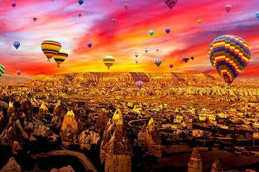
Mount Rinjani , Lombok Island, Indonesia

Mount Rinjani (Mount Rinjani), located in the north east of Lombok Island, is the second highest active volcano in Indonesia with an altitude of 3726 meters. Its first recorded eruption was in 1847. The small volcano Gunung Barujari (Gunung Baru), located within the crater area of Mount Rinjani, spewed ash up to 8000 meters high on April 27, 2009.
Finally, all kinds of trekking activities at a distance of 4 km around the Barujari Volcano, which became active in February 2010, have been stopped. An area of 41,330 hectares covered with rainforest and savanna, with rich plant and animal life, is located in Gunung Rinjani National Park .
The crater lake Segara Anak (Son of The Sea), located in this semi-active volcano, is one of the most important sacred places of Indonesian Hindus. Since the Balinese Karangasem Kingdom captured Lombok in the 18th century, hundreds of pilgrims dressed in white have come here before the rainy season to perform their Mulang Pakelem ceremonies.
Nature exhibits magnificent beauties here; mountain, summit, deep blue crater lake, smoke rising from semi-active volcano, hot springs for resting and cleansing, extraordinary beautiful sunrise and sunset and an ideal climate to enjoy all these.
This national park area is home to long-tailed macaque monkey, Rusa deer (Sunda sambar deer or Timor deer), 55 cm tall barking deer (Barking deer), wild boars, Bengal Cat, parrots and numerous birds and animals. It hosts a variety of insects. The Indonesian government has applied for inclusion in the UNESCO Geological Park List.
Climbing the 3,726 m summit of Mount Rinjani requires good conditioning, equipment and preparation. Unfortunately, the tragic deaths of people without these qualifications are in the park’s history. Climbing up to the campsite at the edge of Senaru crater at 2700 meters is quite tiring. The 1 km steep slope from the crater rim to the summit is one of the most difficult stages.
Climbing an active volcano

Located in the forest at the 600-meter-high slopes of Mount Rinjani, the small village of Senaru is where most tourists come for a Rinjani climbing or nature vacation. We jumped into an old-fashioned four-wheel drive vehicle that came to pick us up at five in the morning, and another Belgian person named Isabelle joined us from the center of Senggigi.
We intended to sleep on the Senggigi-Senaru road, which is about 2 hours away, but it was not possible due to the exhaust gas filling up inside the vehicle. It was early in the morning and we arrived in Senaru feeling restless, uncomfortable and tired as we were very cold.
We watched the presentation of the tour organization by having our breakfasts. With a climbing team of 17 people from England, Belgium, Netherlands, England, France and Denmark, we jumped in the back of 2 separate pickup trucks that will take us to Sembulan , the village where the Mount Rinjani National Park office is located. At the entrance of the park, a registration is made in the book and the entrance fee is 150.000 Rupiah. Then we returned to the village a few kilometers back.
We started our walk from Sembulan village at 10:30 am as 8 porters (carriers), 2 guides and 17 people. In the first 10 km of hiking trail, we passed through rice fields, green bean orchards and partly forest and dry streams, and then we walked through the forest again.

Contrary to all the beauties, nature is treated quite ruthlessly here. All along the route there are pet bottles, plastic wraps and bottles all over the place. Although the Mt.Rinjani Trek Center, which manages the Gunung Rinjani National Park we are in, has received an award, it cannot be said that the management manages the park well.
Almost all of the hiking trails consist of paths, arrangements have been made in very few places. When I see the hiking trails in Australia and New Zealand, it is impossible not to criticize the officials here. There is not a single toilet on these kilometers of trekking route.
There are no resting huts and canopies along the route. There is no shop where you can buy anything you need. The porters carrying our loads have biscuits and some drinks displayed on their sarongs that they lay on the ground at the campsite, probably many are hungry. Because the food and drinks served during the camp are far from providing enough energy for climbing.
When we arrived at the resting point called Montong Satas at an altitude of 1500 m after 3 hours, we took a lunch break, we were now at the level of the clouds. We all sprawled across the meadows, almost devastated. A local dish packed in not-so-clean plastic sheets and a side of rice porridge was delicious.
It is useful to remember when you say rice pilaf; In Asia, rice is served simply boiled. This is how rice is served, which replaces bread, not only in Asia, but also in New Zealand and Australia. After the tea service with plastic cups after the meal, we set off again.

Since the side of the mountain we were on was completely in the clouds, we were walking in the constantly moving fog that surrounded us. We were walking in beautiful weather conditions, but now our walking path was starting to get steeper.
We started to have difficulties, the short breaks given were not enough to rest. We were in a hurry to reach the campsite, where we will spend the night on the crater shore, before the sunset. After a 2-hour trek, we took a 5-minute break at the Mondokan Lokak resting point at 2000 m.
The ascent, which started at 10.30 in the morning, ended approximately 7 hours later on the rim of the 2,641-meter-high Senaru Crater , which has a fascinating and dazzling view . With the red color of the sunset painting all over, we were met with a breathtaking view wherever we looked. We settled in positions that we found sheltered from the wind to take pictures and enjoy the scenery.
700 meters below, the active volcano Gunung Barujari (Baby Volcano) and the blueness of the surrounding Segara Anak crater lake were an extraordinary sight. On the other hand, the popular holiday destination Gili Islands (Gili Air, Gili Meno, Gili Trawangan) and Bali were before our eyes.
There were more than fifty tents set up by other tour organizations in the camping area. The air temperature was around 4-5 degrees, and when I couldn’t feel my fingers anymore, I went to my tent and got into my sleeping bag. In this organization, sleeping bags and mats are provided to you, but if you have your own sleeping bag, the porters carry it for you.

I slowly started to warm up. Along the way, Dutch Heleen and Kirstin, whom we befriended, and Isabelle and Farid from Belgium, crowded into our tent in the French Douglas, who will share the same tent with me. We met and chatted under the light of our head lamps.
We arrived at the campsite at 18:00, but we were able to have dinner at 21:00. Without even waiting for the tea to be served after the meal, everyone decided to go to their tents and sleep. After 5 hours, we have to wake up at 3 am to climb Mount Rinjani’s peak at 3726 meters. A challenging climb and a wonderful sunrise await us.
Day 361: Indonesia:19 Mount Rinjani, 2.641. meters, Lombok, 31 July 2011
Being above the clouds at the summit of Mount Rinjani
We reached the crater mouth at 2700 meters from the village of Senaru at 600 meters with a 7-hour climb yesterday, after a very tiring 7-hour climb. We woke up at 3 am to start climbing the summit. For the night temperature of 4-5 degrees at this altitude of 2,700 meters, the comfort of my sleeping bag was too much and I woke up frequently from the heat.
We started the climb without breakfast. The weather is windy and cold. You sweat as you walk and you feel the cold effect of the wind more intensely. Mount Rinjani is a volcanic mountain and it is as if you are climbing in a steep desert as the rocks where we walk crumble into grains of sand and gravel.
With each step you take, you slide back half a step. I was short on equipment. I don’t have suitable mountaineering shoes on my feet, nor do I have light clothes that protect from the wind, I don’t even have a head lamp.
I had to follow the lights of the light sources that those in front of and behind me had attached to their heads, otherwise it is not possible for me to see in front of me in this darkness. The only road to the summit is quite steep and the right and left of the trail slopes 45 degrees. It is possible to take a wrong turn or possible falls and find yourself hundreds of meters below, if you are still alive.
It is not dangerous if you take the necessary precautions, follow the guide and walk carefully. We were all out of breath on our ascent to the top as there was hardly any easy trail. We often take a break, but this time you feel the cold inside.
Every time you get closer to the top, the strength of the wind increases. It is not possible for us to walk together with our group of 17 people, some of them are far behind, some of them are already half way. We mingle with the climbers of other tour organizations on the way.
In the last half hour of our climb, we were able to travel without the need for headlamps, as the day started to dawn, but the effect of the wind was unbearable. Finally, 3.5 hours later, at sunrise, we were at the top.
We might be sleeping soundly in our hotel bed now, but all the hardships we endure are worth it because of the challenging feeling of being at the top, the highest, and the enchanting view of the sunrise that paints the sky a blood red.
I had seen a wonderful sunrise in Nemrut before, but it was very different here. The clouds are lined and drawn with a red pen, and you can see the sunrise from behind these clouds, second by second. A round red ball rises above these pink, orange and red clouds.

Our toes and fingers were numb to a degree that was no longer felt. My companion Farid’s mood was not suitable for taking pictures, we were quite tired and cold. Since I don’t have my own camera, I took his camera and took as many pictures as I could.
I approached a French man who had lit a small fire and warmed my fingers in the fire he had lit. In return, I took an apple out of my bag and gave it to him, but he couldn’t keep it in his fingers because of the cold, but he could only eat half of it. We spent only 10 minutes at the top and started descending. We can only fix every step we take a few steps further, because it is impossible to stay still in the sand below us.
I regained my balance and started walking down with half-running steps. With every step, your feet are buried in volcanic sand up to your ankles, and the inside of your shoes are filled with sand and pebbles. Even though these sands like sandpaper hurt your feet, I didn’t care for the desire to get downstairs and warm up as soon as possible.
After we were halfway through and warmed up, we started to descend with slow steps, resting and taking pictures. It was very difficult to climb and it seemed impossible, but we succeeded, but this time the descent path was never ending. Since our bodies were now exhausted, we started to descend with slower steps.
It took 4 hours to return from the summit to the campsite. While those who arrived before me were having their breakfast with pancakes and tea, there were hundreds of monkeys around us. Some mountaineers were throwing a piece of the pancake in their hand, and the monkeys were coming and taking the pancake and leaving quickly.
We rested for 1 hour at the campsite where we stayed last night, located on the edge of the crater, at 2700 meters. Our next route will be the Segara Anak Crater Lake, 700 meters below, and the hot springs near it.
Swimming in extraordinary crater lakes
After resting for 1 hour at the campsite where we stayed last night, at 2700 meters at the crater mouth, we set off again. This time our target will be the sacred Segara Anak Crater Lake 700 meters below and the hot water pools near it. The path going down is both risky and very steep.
These kind of paths that we descend in zigzags seem easier to me. Due to my childhood experiences, my ability to walk on rocks and balance is very good. The problem with this descent is the excessive strain on your leg muscles due to the load on your knees. That’s when my pain started in the ligaments in my left knee, which I had hurt while playing tennis before.
After descending the difficult road from the steep crater mouth to the center of the crater, we walked through the paths between the meadows in the valley inside the crater. The air temperature hovers around 16°C. At 3 pm, we immersed ourselves in the cool waters of the 200 meter deep Segara Anak Crater Lake.
When we learned that food preparation would take a long time, we went to the Aik Kalak hot springs, which is a 15-minute walk from the crater lake . Would it be more accurate to say spa? While the cold water in the crater lake is around 20 degrees, the temperature of the water that warms up through the volcano and reaches here is around 37 degrees in places.
Some of the pools are too hot and too hot for swimming. We took a dip in one of the appropriate pools and solved the cramps in our muscles. We got rid of the dust, sand and dirt that were everywhere for two days and relaxed.
The hot spring water named Pangkereman Jembangan is mixed with coconut oil by the local people to make ointments and is said to be a cure-all.
Yesterday we camped at 2,000 meters on the eastern summit of the crater mouth. Our campsite tonight will be in the rainforest outside. Normally our accommodation would be on the summit at the north exit of the crater rim, but since we have almost exhausted all the water needed for cooking, we will camp where the natural water source is.
We started the hike from the lakeside, but there are no shores or trails to follow. Clinging to the cliffs along the lake shore, we crossed this steep and dangerous path, which is as beautiful as it is beautiful. The water was clear enough to see huge fish swimming in the crater lake. Our guide was telling us to be careful, 2 English girls died because of the love of taking pictures on this track.
When we reached the summit by crossing the steep slopes and cliffs through the forest, and climbing from time to time, an incredible view awaited us again. From the valley on our left, which is the only exit of the crater, we could see the clouds filling into the crater with the drag of the winds.
On the other hand, the blue color of the crater lake, the clouds, and the forest displayed an insatiable sight. Just behind us, the head of the rainforest is covered with clouds. From the airplane window there was a view of clouds shimmering in the sun. We are walking perhaps 1,000 meters above the clouds.

There were also many camping tents on this summit we reached. Tents were set up on the road we passed, as well as by the lake. It would be more enjoyable to do this route for 5 days instead of 2 nights and 3 days and to watch and experience all the beauties of nature. I told my fellow traveler Farid that we should buy tents or equipment and organize our own route, but he did not accept it.
In fact, those who want can rent your own porter and guide and plan comfortably as they wish. There is no need for a guide, just a porter to hire Rp 100,000 per day and some equipment can be rented from the village. We were told that the campsite was 2 hours away, and as we started walking there again, the sun was about to set.
Of course, the resulting landscape, the appearance and colors of the Agung and Batur mountains on the island of Bali, to the west of Lombok island, as if rising from the clouds, are of the beauty that can be legendary. While our group was advancing rapidly, we stayed behind with Isabelle from Belgium and our Dutch teammates Farid, Heleen and Kirsten, walking slowly and taking lots of photos.

This hike was once again an adventure. When Farid also went fast to catch up with the group in front, the rest of us were walking downhill in the dark with weak light sources, taking very slow small steps downhill, sand or dirt roads.
When we finally got to the rainforest, we relaxed a bit, because the path was more firm and clear because of the trees. Only this time, tree roots slowing us down and girls stuck on footpaths eroded by rain in some places caused him to fall a few times.
It’s easy to hurt or break a part of yourself when you’re not careful. We were only able to cross this path in 3 hours, which the porters with their loads on their backs crossed in 1 hour. When we arrived at the campsite, our team was drinking tea around a big fire in the rainforest, in front of the tents they set up among the trees. We took our place around the fire, we were very tired and exhausted.
After dinner, we went to our tents. We were told to leave our shoes inside the tent. There are wild dogs living in this rainforest. It has been reported that our shoes can be stolen by curious monkeys and dogs. On the way, we saw a few wild dogs living in the forest.
After a descent expected to take 4.5 hours tomorrow, this Mt. We will have finished our Rinjani climbing adventure.
Day 362: Indonesia:20 Mount Rinjani Rainforest, Lombok, 1 August 2011
Camping in the Rainforest
Mount Rinjani National Park is one of the most popular activity centers of Lombok Island. Located in the National Park, the semi-active Mount Rinjani volcano is a favorite of mountaineering enthusiasts. We had purchased the 2 nights and 3 days climbing tour to the Rinjani Volcano in the town of Senggigi, located in the east of the island.
On the evening of our first day of climbing Mount Rinjani Volcano, we camped at the mouth of the crater at 2700 meters. We started our trek to Mount Rinjani above the clouds at 3 am the next day and reached the summit at 3726 meters.
We swam in Segara Anak, the crater lake of Mount Rinjani, the Hindu holy mountain, and rested our muscles in its hot spring. On this last day of this 40-kilometer-long climb, we will pass through the rainforest and return to Senaru village.
When we woke up in the morning, there were dozens of monkeys jumping around, waiting to steal or buy food from us around our tents. It was the same view as at our first campsite at 2,700 meters where we camped the night before, but the only difference was that this was the rainforest.
We started our walk after breakfast at 6 am to complete our last 4.5-hour walk today through these rainforests and return to Senaru village. Maybe it was one of the most beautiful and hardest walks for me.
While it is possible to see monkeys jumping from tree to tree and sometimes wild dogs wandering around the forest, you should be careful not to trip over the tree roots on the path, which includes steps and on the other hand. It seemed quite possible to me to get a foot or toe stuck between the tree roots covering the whole path and break it.
If a smooth and safe path had been prepared, it would have been much more enjoyable to walk by watching the beauties around you. The aim was not only to increase walking and performance, but also to be aware of these natural beauties and to walk by feeling. As if the path was formed by natural walking, it contains many zigzags and steps and became challenging after 2 days of fatigue.
I was walking with difficulty due to the problem in my left knee ligaments from previous roads. This time I was left behind, accompanied by a young 18-year-old guide. Yesterday, this guide accompanied us when we lagged behind the group.
In fact, one of the biggest reasons we lag behind is that we stop and take pictures. I wouldn’t want to walk the last 4-5 hours in this beautiful rainforest just by looking at the obstacles in front of me. We would catch up with the group at the resting points and then set off together again.
The next walk was easier. We walked on the wider and smoother roads passing through the villages, between the banana trees, with the peace and comfort of having succeeded in a difficult walk and climb. We had completed a 40 km long hike, most of which consisted of challenging tracks. We were finally at the Mount Rinjani National Park’s office near the village of Senaru.
We rested at the agency’s hotel, where we first gathered. While some of the travelers were going to the Gili Islands, together with Dutch Farid, Heleen, Kirstin and Belgian Isabelle, we got on our shuttle vehicle bemo (minibus) and returned to our hotels in Senggigi . We could hardly climb the hotel stairs due to our pain.
During our trek on the 40 kilometer challenging trails of Mount Rinjani , we saw 2 stunning sunsets, 1 magnificent sunrise, swam in the crater lake, relaxed in the hot pools heated by the lava, walked on and in the clouds, camped in the rainforest and at the rim of the crater, saw monkeys, birds and we walked with wild dogs, drank from natural springs, we were tired, sweaty and dirty.
Now was the time to rest, relax and celebrate the pain in our muscles.
Day 363: Indonesia:21 Senggigi, Lombok, 2 August 2011